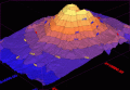
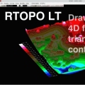
Loading and drawing XYZ files of points, triangulation, contour lines and color-filled contour maps. You can also draw 4D points cloud and process hundreds of thousands of points or triangles, even on less powerful PCs.
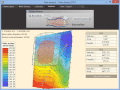
Terra Excess is land surveying and civil engineering CAD software developed to be extremely intuitive. It can be used for creating topographic plans and maps, calculating stockpile, quarry and earthwork volumes or editing and viewing survey points.
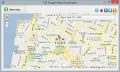
Easy Google Maps Downloader is a tool that help you to get small tile images from Google maps. You can view downloaded maps by Maps Viewer Or you can combine them into a big BMP map by Maps Combiner.
Universal Maps Downloader is a tool that help you to get small tile images from google maps, yahoo maps, bing maps, openstreet maps. You can view downloaded maps by Maps Viewer Or you can combine them into bmp, jpg or tif file by Maps Combiner.
Easy Yahoo Maps Downloader is a tool that help you to get small tile images from Yahoo maps. You can view downloaded maps by Maps Viewer Or you can combine them into a big BMP map by Maps Combiner.
Google Maps Downloader is a tool that help you to get small tile images from Google maps. You can view downloaded maps by Maps Viewer Or you can combine them into a big BMP, TIF, or JPG file, or mbtiles file.
Easy Ovi Maps Downloader is a tool that help you to get small tile images from Ovi maps. You can view downloaded maps by Maps Viewer Or you can combine them into a big BMP map by Maps Combiner.