|
|
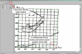
DigitGraph
The Digit Graph program is meant for the manual digitization of graphic dependences presented as the BMP bitmap images. In concordance with the purpose, the program enables to take point coordinates from the diagram by means of the computer mouse. Ключевые слова:
manual, digitization, interpolation, dependency, graphics
Скачать бесплатно! (2.4 Mb)
|
|
|
TOPOWIN
TOPOWIN is a state-wide register of the German topographic cartographies and of localities with geo references in different coordinate systems. It also is a topographic information system. Ключевые слова:
geodauml, tisch, funktionen, library, dll
Скачать бесплатно! (4.06 Mb)
|
|
|
ORTWIN English
ORTWIN is a program for the inquiry of localities in Germany. It finds postal zip codes, telephone pre selections, coordinates. It performs perimeter searches and distance calculations. It finds landscapes, natural units, snow- and wind load zones. Ключевые слова:
natue, area, areas, landscape, landscapes
Скачать бесплатно! (3.7 Mb)
|
|

|
TOPOWIN English
TOPOWIN is a state-wide register of the German topographic cartographies and of localities with geo references in different coordinate systems. It also is a topographic information system. Ключевые слова:
geodetic, geodesic, functions, library, dll
Скачать бесплатно! (3.42 Mb)
|
|

|
Javascript Game Script
This is a free game engine developed for programming browser based games. It uses Javascript language and CSS to dress up the page. They run pretty reliably together. Use this engine to create your own game. Ключевые слова:
css, javascript, games, game, gaming
Скачать бесплатно! (1.03 Mb)
|
|

|
Javascript Game Engine
This is a free game engine developed for programming browser based games. It uses Javascript language and CSS to dress up the page. They run pretty reliably together. Use this engine to create your own game. Ключевые слова:
css, javascript, games, game, gaming
Скачать бесплатно! (934 Kb)
|
|
|
?????»????????: ???????µ???‚ ???µ?¶?µ???°??????
Полигон: Проект межевания - это программа для оформления проекта межевания земельных участков, составляемого в соответствии с требованиями, утвержденными приказом Минэкономразвития РФ от 3 августа 2011 г. №388. Ключевые слова:
Range the land surveying Project, land surveying automation, tap of the earths
Скачать бесплатно! (5.04 Mb)
|
|

|
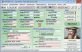
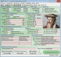
Meet the Team and Biography
This takes the Team Member, Meet the Staff type image viewer in a different direction. Given a photo of a group of people, you create rectangles around the people and store the coordinates in an XML file. Then you create a text file about each person Ключевые слова:
flash components, actionscript, video player, audio, flash galleries
Скачать бесплатно! (4.88 Mb)
|
|
|
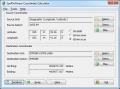
Eye4Software Coordinate Calculator
Eye4Software Coordinate Calculator is a very easy to use tool to perform gps coordinate conversions. Supported projections: Transverse Mercator, Lambert Conformal Conic, UTM, Gauss Kruger, Stereographic, Albers Equal Area, Oblique Mercator and more. Ключевые слова:
Coordinate Conversion, Coordinate Calculator, Convert Coordinates, GPS Coordinates Conversion, Map Datum Conversion
Скачать бесплатно! (8.96 Mb)
|
|
|
VISeismo
- Alarm level and all last quakes around the place you have selected
- you can select any place at the Earth from the list or add any new places you need for
- the quakes are shown as a radial lines an pies Ключевые слова:
earth, quake, monitor, alarm, science
Скачать бесплатно! (4.56 Mb)
|
|
Страница: 1
| 2
| 3
| 4 | 5
|
|
|
|