|

|
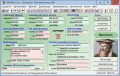
CopanMobile for PalmOS
Copan for PalmOS enables you to COGO (do coordinate geometry), process field surveys, adjust map traverses, perform map/deed checks, calc curves and areas/perimeters, transform coords, interface with GPS, and import/export Ascii files. It's free. Ключевые слова:
free land survey software, free cogo software, free coordinate geometry software, coordinate geometry calculator, field data processing
Скачать бесплатно! (341 Kb)
|
|

|
SEVENPAR (English)
SEVENPAR calculaties exact parameter sets for the Spatial Helmert or Molodensky Transformation with seven or three parameters, which are used for accurate geodetic datum shifts between different reference systems for coordinate transformations. Ключевые слова:
spatial, helmert, molodensky, molodenski, transformation
Скачать бесплатно! (2.48 Mb)
|
|

|
Copan for Windows
Copan for Windows enables you to calculate coordinate geometry (COGO), process field surveys, adjust map traverses, perform map/deed closure checks, calculate areas and perimeters, transform coordinates, and import/export Ascii files. It's free. Ключевые слова:
land survey software, cogo software, coordinate geometry software, coordinate geometry calculator, field data processing
Скачать бесплатно! (5.37 Mb)
|
|
|
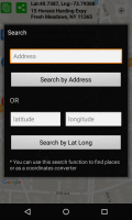
Latitude Longitude
Latitude and Longitude app for android allows you to get or share map coordinates of your current location. share your current gps location with anyone using GPS coordinates, address or both. Ключевые слова:
Latitude Longitude, GPS Coordinates
Скачать бесплатно! (2.44 Mb)
|
|

|
SEVENPAR
SEVENPAR calculaties exact parameter sets for the Spatial Helmert or Molodensky Transformation with seven or three parameters, which are used for accurate geodetic datum shifts between different reference systems for coordinate transformations. Ключевые слова:
geodetic, program, helmert, molodenski, seven
Скачать бесплатно! (2.24 Mb)
|
|
|
SEVENPAR Deutsch
SEVENPAR calculaties exact parameter sets for the Spatial Helmert or Molodensky Transformation with seven or three parameters, which are used for accurate geodetic datum shifts between different reference systems for coordinate transformations. Ключевые слова:
sevenpar, programm, helmert, 7Parameter, molodenski
Скачать бесплатно! (1.68 Mb)
|
|
|
SEVENPAR English
SEVENPAR calculaties exact parameter sets for the Spatial Helmert or Molodensky Transformation with seven or three parameters, which are used for accurate geodetic datum shifts between different reference systems for coordinate transformations. Ключевые слова:
geodetic, program, terminal, service, citrix
Скачать бесплатно! (1.66 Mb)
|
|
|
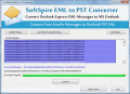
Importing EML files into Outlook
Figuring out tool for importing EML files into Outlook, but not getting rite converter for EML to PST Conversion. So EML to PST Converter is best tool for importing EML files into Outlook. Software support graphical view and well coordinate with all Ключевые слова:
importing eml files into outlook, import eml messages to outlook, import eml files into outlook, how to import eml files into outlook 2010
Скачать бесплатно! (2.4 Mb)
|
|
|
TOPOWIN English
TOPOWIN is a state-wide register of the German topographic cartographies and of localities with geo references in different coordinate systems. It also is a topographic information system. Ключевые слова:
geodetic, geodesic, functions, library, dll
Скачать бесплатно! (3.42 Mb)
|
|
|
WinDraw
This software utility can plot regular or parametric functions, in Cartesian or polar coordinate systems, and is capable to evaluate the roots, minimum and maximum points as well as the first derivative and the integral value of regular functions. Ключевые слова:
function, graph, plot, parametric, polar
Скачать бесплатно! (1.18 Mb)
|
|
Страница: 1
| 2 | 3
| 4
| 5
|
|
|
|