Automapki 1.5.1
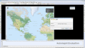
Automapki application brings web mapping to AutoCAD / ZWCAD / BricsCAD to display your project on top of your favourite web mapping source: either Open Street Map, Map Quest, Open Aerial, or any user defined WMS base layer.
$50.00
Скачать (32 Mb)