OpenGL Coordinates Tutorial with full Delphi Source Code. Tutorial on how to convert 2D mouse screen coordinates to 3D OpenGl world coordinates and how to draw with mouse in a 3D world.
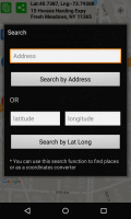
Latitude and Longitude app for android allows you to get or share map coordinates of your current location. share your current gps location with anyone using GPS coordinates, address or both.
Geozip calculates distance between US (optionally Canadian) zip codes or geographical coordinates. You can choose miles, kilometers or nautical miles output.
With this tool you can add GPS coordinates to vCards - elektronic business cards. Therefore the tool uses the address data contained within the vCards and adds the exact GPS position on that basis to the vCard.
Полигон: Проект межевания - это программа для оформления проекта межевания земельных участков, составляемого в соответствии с требованиями, утвержденными приказом Минэкономразвития РФ от 3 августа 2011 г. №388.
SEVENPAR calculaties exact parameter sets for the Spatial Helmert or Molodensky Transformation with seven or three parameters, which are used for accurate geodetic datum shifts between different reference systems for coordinate transformations.
Arm Map Explorer recreates all the functionalities of Google Maps while adding new ones like viewing a map with a coordinate grid on it, getting precise coordinates of any location on a map, moving to a needed location based on specified coordinates.
RapidDXF reads ASCII (text) or XLS (Microsoft Excel) files of coordinates and creates DXF (version 12) files of points and thier attributes. The DXF files so created are usable in many CAD software. RapidDXF can process several files at a time.
Panorado Flyer is a simple geocoding tool for linking JPEG image files to the location where the picture was taken, using geographical coordinates. It can be lauched from the Windows Explorer's context menu.