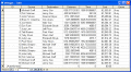
Batch calculate distances, travel times, and/or costs for point-to-point routes listed in a database (Access, Excel, or ODBC). Uses MapPoint for point locations and route calculations. Supports all of MapPoint's route options.
The back and forward view change buttons were removed in MapPoint 2009. The Back and Forward Utility implements this functionality as two menu items on the Tools menu. Software is freeware and open source (Berkeley) see site pages for details.
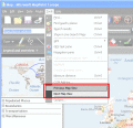
Imports and Exports MapPoint waypoints and pushpins in route-order. MapPoint always re-arranges pushpins when it does this. Exports routes directly to Excel, or you can create a route from pushpins in a pre-determined order.
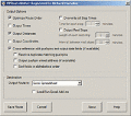
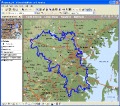
Microsoft MapPoint add-in that performs cluster analysis on MapPoint pushpin (point) data. Clusters can be drawn as map annotation (centroid pushpins and/or cluster boundary shapes) and exported to Microsoft Excel. Supports a range of size options.
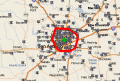
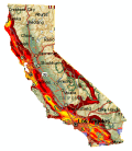
US State Mapping Template consists of Microsoft MapPoint templates that enable you to create maps of individual (or combined) US States and Counties. Supports MS MapPoint 2002 and later (North American Edition only).
North American Mapping Templates consist of Microsoft MapPoint templates that enable you to create maps of individual (or combined) US States & Counties; and Canadian Provinces. Supports MS MapPoint 2002 and later (North American Edition only).
MPSuperShape is a shape manipulation tool for Microsoft MapPoint. MPSuperShape can combine shapes, find overlaps, find boundaries, and import/export various files. MapPoint 2006, .NET Framework 2.0 (or later), and Windows XP or Vista required.
Calculate Mileage Charts and Tables with Microsoft MapPoint. Calc. tables for customers and suppliers incl. "closest only", or to create "road atlas" tables. Output Distances, travel times and/or estimated costs to Excel. Supports ALL route options.
CDXZipStream is a complete solution for analyzing address and census data into Microsoft Excel. CDXZipStream features geocoding, maps, zip code reports, reverse look-up, distance and radius calculations. Optional demographic data feeds are available.