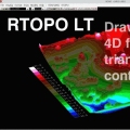
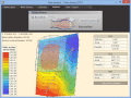
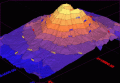
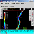
|
|
Terra Excess
Terra Excess is land surveying and civil engineering CAD software developed to be extremely intuitive. It can be used for creating topographic plans and maps, calculating stockpile, quarry and earthwork volumes or editing and viewing survey points. Ключевые слова:
land surveying, civil engineering, topographic, contour lines, contour map
Скачать бесплатно! (32 Mb)
|
|
|
VisionLab VCL
Delphi/C++ Builder Basic Computer Vision Library. Motion, and Image recognition (Canny, Hough Lines, Contour Finder, and more.). Allows rapid development with almost zero lines of code. Includes video capture components. Free for non-commercial use. Ключевые слова:
Computer Vision, Motion Detect, Object Tracking, Canny, Hough
Скачать бесплатно! (32 Mb)
|
|
|
VisionLab VC++
Visual C++ Advanced Computer Vision Library. Motion, and Image recognition (Canny, Hough Lines, Contour Finder, and more). Allows rapid development with zero lines of code. Includes video capture components. Free for non-commercial use. Ключевые слова:
Computer Vision, Motion Detect, Object Tracking, Canny, Hough
Скачать бесплатно! (32 Mb)
|
|
|
3DField
3DField is a contouring plotting and 3D data program. It converts your data into contour maps, surface or volume plots. Rotate image Ключевые слова:
3D, map, contour, gridding
Скачать бесплатно! (3.15 Mb)
|
|
|
Visual Data For Academic
Scientific data visualization software. Creating vertex, grid and surface model, color map, contour plot, vector plot, 4D scatter, 4D slice and 4D vector. Ключевые слова:
visual data, data visualization, data visualization software
Скачать бесплатно! (3.15 Mb)
|
|
|
Falco Lines II
Логическая игра Lines c красивой анимированной графикой, спецэффектами, и джазовой музыкой. Ключевые слова:
falco lines, lines
Скачать бесплатно! (10.7 Mb)
|
|
|
RTOPO
Simple, powerful and inexpensive CAD software for surveying. You can do triangulation, isolines, color-filled contour maps, sections, intersections, volume and editing XYZ files. You can process hundreds of thousands of points or triangles. Ключевые слова:
CAD for Topography, XYZ File editor, LandXML, Triangulation, Isolines
Скачать бесплатно! (1.04 Mb)
|
|
|
RTOPO Hydrology
Simple, powerful and inexpensive CAD software for surveying. You can do triangulation, isolines, color-filled contour maps, sections, intersections, volume, simulation of rainwater runoff and editing XYZ files. Ключевые слова:
CAD for Topography, XYZ File editor, hydrology, LandXML, Triangulation
Скачать бесплатно! (2.48 Mb)
|
|
|
Swap Lines In Multiple Files Software
Randomly swap all lines or swap specific line numbers in one or many files. Ключевые слова:
swapping, swapper, line, change, exchange
Скачать бесплатно! (759 Kb)
|
|
|
VB 6 Pure Code Lines Calculator
Do you still use Visual Basic 6? If so, you can try VB 6 Pure Code Lines Calculator! It is a 100% FREE CASE tool for VB6. Use it to calculate PURE code lines (writing manually) for VB6 project with the automatic version history recording feature. Ключевые слова:
count vb6 code lines, count vb6 pure code lines, count vb6 plain code lines, vb6 code lines counter, vb6 code lines calculator
Скачать бесплатно! (813 Kb)
|
|
Страница: 1 | 2
| 3
| 4
| 5
|
|
|
|