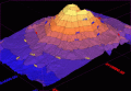
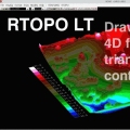
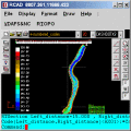
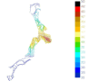
Loading and drawing XYZ files of points, triangulation, contour lines and color-filled contour maps. You can also draw 4D points cloud and process hundreds of thousands of points or triangles, even on less powerful PCs.
Terra Excess is land surveying and civil engineering CAD software developed to be extremely intuitive. It can be used for creating topographic plans and maps, calculating stockpile, quarry and earthwork volumes or editing and viewing survey points.
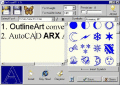
AutoCAD Text Editor - OutlineART,applied in CAD wordprocessing,is a tool to transform words and symbols into vector-contour,we provide both windows desktop version and ARX embedded version for AutoCAD(R14 to 2006)
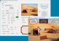
Labeling enriches photos. Useful, if one liked to distribute they. 'FotoBeschriften' is customized. Unskilled users achieve fast good results. Graphic ideas do not only have to be developed and realized pedantically.
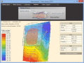
Simple, powerful and inexpensive CAD software for surveying. You can do triangulation, isolines, color-filled contour maps, sections, intersections, volume and editing XYZ files. You can process hundreds of thousands of points or triangles.
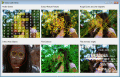
Visual C++ Advanced Computer Vision Library. Motion, and Image recognition (Canny, Hough Lines, Contour Finder, and more). Allows rapid development with zero lines of code. Includes video capture components. Free for non-commercial use.
Simple, powerful and inexpensive CAD software for surveying. You can do triangulation, isolines, color-filled contour maps, sections, intersections, volume, simulation of rainwater runoff and editing XYZ files.