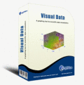
Скачать свежий бесплатный софт
contour
Дом и Обучение :: Математика
Мультимедия :: 3D Моделирование и CAD
Вёб Разработка :: Вёб Дизайн
Scientific data visualization software.

Visual Data For Academic


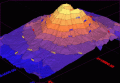
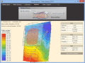
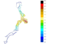
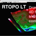
Scientific data visualization software. Creating vertex, grid and surface model, color map, contour plot, vector plot, 4D scatter, 4D slice and 4D vector.

Ключевые слова:
visual data, data visualization, data visualization software

Скачать бесплатно! (3.15 Mb)


Create contour maps. Rotate image

3DField


3DField is a contouring plotting and 3D data program. It converts your data into contour maps, surface or volume plots. Rotate image

Ключевые слова:
3D, map, contour, gridding

Скачать бесплатно! (3.15 Mb)


Land surveying and civil engineering software

Terra Excess


Terra Excess is land surveying and civil engineering CAD software developed to be extremely intuitive. It can be used for creating topographic plans and maps, calculating stockpile, quarry and earthwork volumes or editing and viewing survey points.

Ключевые слова:
land surveying, civil engineering, topographic, contour lines, contour map

Скачать бесплатно! (32 Mb)


TRIANGULATION,ISOLINES,VOLUME,3DINTERSECTION

TRIANGULATION for IntelliCAD


TRIANGULATION, ISOLINES, VOLUME, LOADING of XYZ points files, 3DINTERSECTION and sections, color-filled contour map ; 7 functions for IntelliCAD versions which can load SDS applications (dll).

Ключевые слова:
TRIANGULATION, ISOLINES, VOLUME, 3D, INTERSECTION

Скачать бесплатно! (587 Kb)


There are very easy to customize via XML.

Maps Package


There are very easy to customize via XML. You don't need to know Flash. The maps are 100% vectorial graphic. Get 20 maps at the price of 6. This package contains: XML Canada Map, XML USA Map, XML Central America, XML South America, XML Europe Map, XM

Ключевые слова:
flash components, actionscript, video player, audio, flash galleries

Скачать бесплатно! (100 Kb)


Interactive Flash World Map using XML

Interactive Flash World Map


An elegant interactive flash map of the world. This interactive world map includes 165 clickable countries. Display country statistics, country-specific information or mark pinpoint locations. The map uses XML and is easy to customize or install.

Ключевые слова:
Flash world map, interactive maps flash, world interactive map, map of the world, XML

Скачать бесплатно! (864 Kb)


Interactive WV Flash Map Driven by XML.

Flash Map WestVirginia


Dongsoft Interactive Flash Maps for websites, interactive map applications, presentations, and more.

Ключевые слова:
WestVirginia Flash Map, Flash Map, Fla Map, Actionscript Map, WestVirginia Map

Скачать бесплатно! (156 Kb)


Interactive Russia Flash Map Driven by XML.

Free Russia Flash Map


Dongsoft Interactive Russia Flash Maps for websites, interactive map applications, presentations, and more.

Ключевые слова:
Russia Flash Map, Flash Map, Fla Map, Actionscript Map, Russia Map

Скачать бесплатно! (156 Kb)


Interactive Brazil Flash Map Driven by XML.

Free Brazil Flash Map


Dongsoft Interactive Brazil Flash Maps for websites, interactive map applications, presentations, and more.

Ключевые слова:
Free Brazil Flash Map, Flash Map, Fla Map, Actionscript Map, Brazil Map

Скачать бесплатно! (156 Kb)


Map several addresses on one Google Map.

Google Maps Plot Multiple Locations Software


Map several addresses on one Google Map layout. Save results as image files.

Ключевые слова:
locations, plotting, plotter, plotable, address

Скачать бесплатно! (811 Kb)


Страница: 1 | 2 | 3 | 4 | 5
Категории:
Свежий софт:
Наши проекты: